|
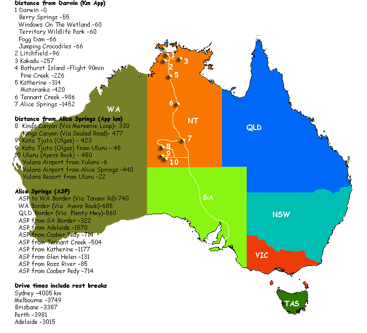
About Stuart Highway from Darwin to Alice Springs things
to do when planning for your self drive Australian vacation
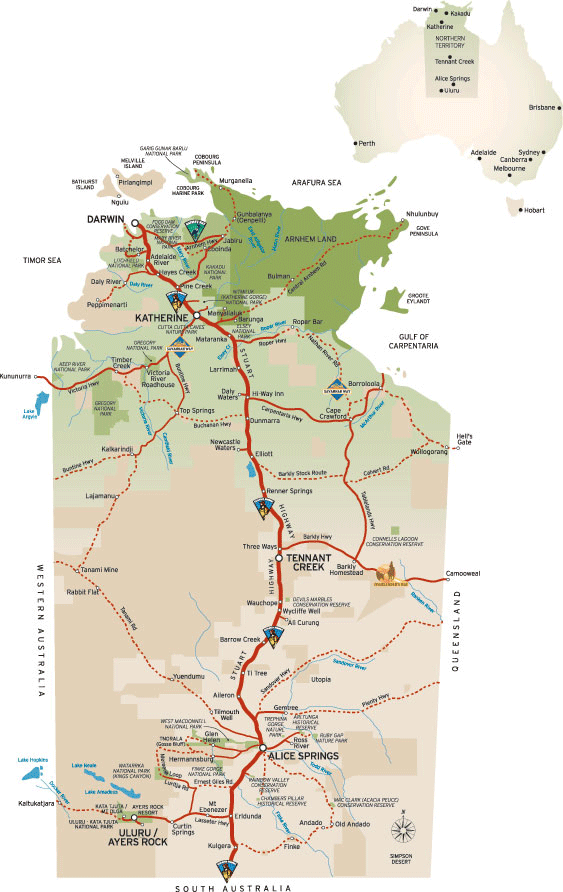
Stuart Highway
Darwin to Adelaide River
- 113 klm
Adelaide River to Katherine
- 203 klm
Katherine to Daly Waters
- 273 klm
Daly Waters to Threeways
- 373 klm
Threeways to Barrow Creek
- 248 klm
Barrow Creek to Alice Springs
- 283 klm
Alice Springs to Darwin - this route is known as the
Explorers Way. At Adelaide River there is a information stand
and the Discovery Trail information sign.
Darwin to Adelaide River
- 113 klm
Darwin
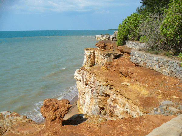
Darwin: Capital city of Northern Territory, Australia is
Darwin. Now Darwin is closer to Jakarta than to Sydney, and also
closer to Singapore than to Melbourne. It is not really a surprise
then that Darwinians looks to Asia for travel, influences in dress
and food as much as it looks south to the rest of Australia. Darwin's
proximity and relationship such as its sister city program with
the Northern Territory's northern neighbours is reflected in Darwin's
cosmopolitan and relaxed tropical atmosphere and culture.
Palmerston
History of the city of Palmerston, Northern Territory. It is app.
22km SE of the Darwin CBD Palmerston is relatively new, having
been established in 1981 as a satellite of Darwin. In August 2000
when our population reached 23,000, now around 25,000.
Berry Springs Nature Reserve
Berry Springs Nature Park protects a large part of the Berry Creek
catchment. Berry Creek begins as a series of springs, forms a
small creek, then reaches Darwin Harbour through a mangrove lined
estuary. The Park provides an attractive area close to Darwin
for recreational activities, and also provides a refreshing swimming
spot after a day at the Territory Wildlife Park. If you swim with
goggles you can see many small native fish and other aquatic life
that live in the clear pools. The Park is open from 8.00 am to
6.30 pm daily. Turn west off the Stuart Highway about 47 km south
of Darwin. The Park is 10 km along the Cox Peninsula Road.
Territory Wildlife Park
Visiting Australia's Northern Territory? Home to an array
of flora and fauna the Territory Wildlife Park showcase one of
the worlds finest nature Parks. Situated in Berry Springs, a 45
minute drive south of Darwin’s CBD, and conveniently located next
door to Berry Springs Nature Reserve the Territory Wildlife Park
truly is the Territory’s wildest wildlife experience! At the Territory
Wildlife Park, not only do you see wildlife up-close in their
natural habitats, you meet them walking through tree top aviaries,
strolling around a natural lagoon and even get to interact with
them during daily presentations. You stroll beneath the surface
in our walk-through aquarium and meet some of the Top End’s most
amazing aquatic life. You meet, nose to nose, with our giant Saltwater
croc. It’s the closest you’ll ever get to a salty without risking
a scratch! Our experienced team love sharing their knowledge of
the wildlife and the habitats in their care. It’s what our people
are passionate about. The more you ask, the happier they are to
share.
Noonamah Store - Noonamah
Tavern - The Noonamah Hotel and, Cafe
Noonamah Store, Noonamah Tavern and 'United' Fuel Stop The
Noonamah Hotel, Cafe and Fuel Stop is on the Stuart Highway, Northern
Territory, Australia. Noonamah is a small town just 46km from
Darwin. Noonamah itself consists of pub and a general store/service
station. The Darwin commercial Crocodile Farm is located here
with over 7000 crocodiles and American alligators.
Noonamah 'United' Fuel Stop
Noonamah 'United' Fuel Stop is excellent for campervans and
4WD rentals as there is ample car p-arks and even for larger motorhomes
and RV's. Noonamah was first settled during World War II when
the army set up a series of airstrips and depots in the area.
Despite being bombed by the Japanese, the airstrips still remain
to this day.
Acacia Hills
Acacia Fuel Stop which is located along side the Acacia Camping
and Van Park.
Turn off to Batchelor then onto Litchfield National Park
If you travel from Darwin the road to Litchfield National
Park one takes is usually via the sealed road called the Stuart
Highway. Batchelor Road meets the Stuart Highway about 92klm down
from Darwin. Then the Batchelor winds into Batchelor and from
Batchelor you drive into Litchfield National Park on Litchfield
Park Road.
Adelaide River to Katherine
- 203 klm
Adelaide River
Adelaide River (Wairia). The photo on the left shows the
Adelaide River main street. OK it's not 5th avenue though it can
busy we have seen 8 cars here at once. The township of Adelaide
River lies on the Stuart Highway 201 km northwest of Katherine
and 114 km south of Darwin and has a population of 159. It is
located near the headwaters of the Adelaide River.
Hayes Creek
Located on the Stuart Highway, 150 kilometers south of Darwin,
Hayes Creek is a gateway to World War II sites and the Northern
Goldfields loop with easy access to Litchfield National Park,
Batchelor, Pine Creek and the Tjuwaliyn (Douglas) Hot Springs
Park.
Hayes Creek Holiday Park:
Considered a hidden treasure, BIG4 Hayes Creek Holiday Park is
situated halfway between Katherine and Darwin and surrounded by
natural wonders. Heritage sites from the World War II and gold
mines are all close by. See thousands of butterflies in the forges
at Hayes Creek or take a relaxing dip in the Douglas Hot Springs.
Emerald Springs Roadhouse
The Emerald Springs Roadhouse was renovated in 2008 and is
now once again the perfect half way spot from Darwin to Katherine.
Facilities • Bar • Restaurant • Beer Garden • Outdoor
undercover deck area • Sixteen En Suite Motel Rooms • Fifteen
Powered Caravan Sites • Fifteen Un-powered Caravan Sites • Coach
& Road Train Parking • Public Toilets & Showers • Pet Friendly
areas • Sixty carparks Services • Food available from 6:00am till
10:00pm daily • Access to clean public showers & toilets • A range
of accommodation • Easy parking for Road trains, coaches, caravans
and cars • Hydro bath for washing of pets.
Pine Creek
Situated 90 kilometers north of Katherine with a population
of 600, the colourful mining town of Pine Creek is at the junction
of Stuart & Kakadu Highway. Pine Creek - Lazy Lizard Caravan
Park - Pine Creek Caravan and Camping: Lazy Lizard Caravan
Park Address: Millar Terrace Pine Creek 847 Tel: +61 (0)8 8976
1019 Fax +61 (0)8 8976 1244. Pine Creek - Diggers Rest Motel:
Diggers Rest Motel, 32 Main Terrace Pine Creek NT 0847 Tel: +61
(0)8 8976-1442 - +61 (0)8 89761458
Leliyn Edith Falls
Leliyn (Edith Falls) on the western side of the Park, is reached
by turning off the Stuart Highway 42km north of Katherine then
following a sealed road for a further 19km.Swimming is
the most popular pastime at Leliyn. Both the lower and upper pools
are excellent swimming spots, as is Sweetwater Pool. They are
open year round, but may be closed due to dangerous conditions
at times during the wet season. Picnic and camping facilities
are provided at the Falls. Limited gas barbecues, tables and an
ablution block with toilet and shower facilities are provided
for your use. There is a kiosk where you can obtain your permit
for camping at Sweetwater, purchase food and drinks and pay your
camping fees. Camping - Leliyn has a landscaped campground
with unpowered sites. Generators are not permitted. Camping fees
apply and should be paid at the kiosk near the picnic area. When
the kiosk is open, campers should pay fees before setting up camp.
After hours visitors should find a site and pay fees at the kiosk
the next day. The campground does become full during the peak
tourist season (June to Sept), and sites are issued on a ‘first
in first served’ basis.
Katherine to Daly Waters - 273 klm
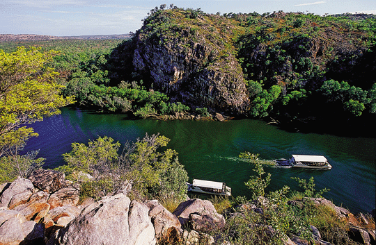
Katherine Gorge - Nitmiluk National Park
This 292,800 hectare National Park is owned by the Jawoyn
Aboriginal people and jointly managed with the Parks and Wildlife
Commission of the Northern Territory. Some of the Park's features
include spectacular dissected sandstone country, broad valleys
and numerous, significant cultural sites. The deep gorge carved
through ancient sandstone by the Katherine River is the central
attraction of the Park. How to Get There: Nitmiluk National
Park is located in the Top End of Australia's Northern Territory.
The Park has two main points of visitor access. The Park's main
entrance is located 30 km northeast of Katherine via a sealed
road. Katherine is located 310 km south of Darwin along the Stuart
Highway. Leliyn (Edith Falls) on the western side of the Park,
is reached by turning off the Stuart Highway 42km north of Katherine
then following a sealed road for a further 19km.
Katherine
Sweeping from the Gulf of Carpentaria to the West Australian border,
the vast Katherine region is full of hidden gems. Often called
the 'Crossroads of the North' because of its location, Katherine
is the fourth largest town in the Northern Territory and is located
312 km south-east of Darwin on the Katherine River. With a population
of over 9,804 people Katherine is a modern thriving regional center
that offers a wide range of services to communities from the Western
Australian border to the Gulf of Carpentaria on the Queensland
border. There is a modern air conditioned shopping centre, hospital,
sports grounds, parks and gardens as well as a large number of
Commonwealth and Territory Government services.
Cutta Cutta Caves Nature Park
Cutta Cutta Caves Nature Park covers 1,499 hectares of limestone
(Karst) landscape, which is limited to only a few locations in
Northern Australia. Spectacular features such as Karst formations
and complex cave networks are a feature of the Park. Tower-like
masses of Tindal limestone with some supporting large boulders
and various surface depressions are other features of this landscape.
How to Get There: Access is via the Stuart Highway 30 km
south of Katherine. The carpark and visitor centre are one km
from the Highway along a sealed road.
Springvale Homestead Tourist Park
Situated 7kms from Katherine township on the banks of the
Katherine River, Springvale Homestead was built in the 1880’s
and is the oldest standing Homestead in the Northern Territory.
It is renowned for its hospitality and relaxed atmosphere. Springvale
Homestead offers travellers a shady parkland environment, featuring
grassed caravan and camping sites, budget motel accommodation,
a licensed bistro and kiosk, swimming pool and children’s waterslide.
Relax, wander the picturesque grounds with wallabies roaming freely
and take in the beauty of the original Homestead. Free Homestead
Tours operate daily at 3:00pm from May to September except Saturday
and public holidays. Learn about the history and enjoy a devonshire
tea.
Mataranka
The small township of Mataranka sits on the upper reaches
of the Roper River, an hour’s drive south-east of Katherine. This
tropical wayside stop is on the Explorer’s Way tourism drive,
the main artery that connects Adelaide and Darwin, and is renowned
for its thermal pool – a sandy-bottomed lagoon fringed by palm
forest and a rejuvenating swimming spot for weary travellers up
and down ‘the track’. Although the township itself is small, with
a population of about 250, it services outlying cattle stations
and Aboriginal communities so is well equipped with facilities
for travellers.
Mataranka Thermal Springs
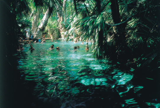
Mataranka Thermal Pool: The Mataranka Pool is fed
by spring water from the Daly and Georgina basins at a volume
of 30.5 million litres per day. It is surrounded by a palm forest
and maintains a constant temperature of 34 degrees, making it
an ideal place to relax, swim or camp overnight. The
Mataranka Thermal pool is the biggest draw card to the region.
Nestled amongst tall shady Mataranka Palms (Livistonia ....) the
thermal pools pump out a tremendous amount of warm water which
has soothed many a traveller over the years. Only a stones throw
from the Roper River, the turquoise waters of the main pool add
to the atmosphere of the springs.
Bitter Springs at Mataranka
Bitter Springs Mataranka NT When travelling through Mataranka
and you are looking for a nice relaxing place to have a dip and
actually stretch out and do some laps, try Bitter Springs Thermal
pool instead of the well frequented Mataranka Thermal pools.The
springs here actually branch off into a stream which you can follow
down 100 metres to a bridge & ladder to climb out of then go for
a walk around the springs. Consistently deeper than the Mataranka
thermal pools, Bitter Springs wasn't suited for very young children
(under 8's). But much quieter.
Elsey National Park
Elsey National Park, eight kilometers from Mataranka, is another
of the region’s natural attractions. The massive Roper River slices
through this 140 square-kilometre expanse, flowing through large
waterholes then tumbling over rocks and tufa dams. Canoeing and
fishing are popular activities and swimming is great at Bitter
Springs and the Thermal Pool. Scenic riverside walking tracks
to Mataranka Falls are a great way to explore the Park overland.
The Rainbow Springs and Thermal Pool sector of the Park are a
major attraction for visitors. The spring water rising from underground
at 30.5 million litres per day and at a temperature of 34 Degrees
Celsius is then contained in a relaxing swimming pool surrounded
by a palm forest.
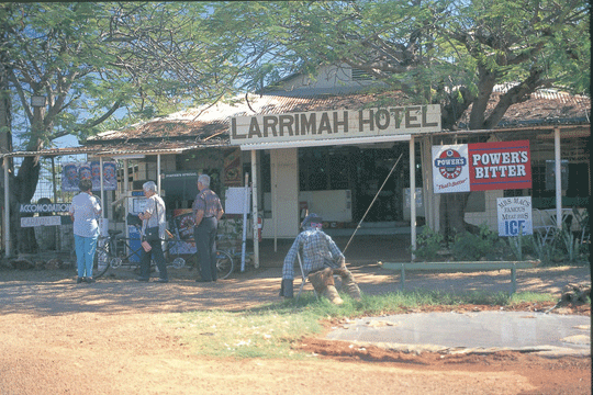
Larrimah
In open tropical woodlands 75 kilometers south of Mataranka,
Larrimah is a former railway town good for a stopover. The town
consists of three main establishments which provide a good variety
of accommodation and services, and the nearby ghost town of Birdum
is fun to explore.
Daly Waters to Threeways - 373 klm
Daly Waters
Daly Waters can be found about 270 kms south of Katherine, close
to the junction of the Carpentaria and the Stuart Highway. Daly
Waters Pub is on the Stuart Highway actually near the intersection
of Stuart Highway and Carpentaria Highway. A township which comprises
a few houses and the very famous Daly Waters Hotel. The annual
Daly Waters Rodeo is a Northern Territory local icon event.
Dunmurra
Dunmarra is a roadhouse 314 km south of Katherine on the Stuart
Highway. Caravan park with lawned sites, large swimming pool and
new amenities with budget air conditioned Motel accommodation,
fuel and autogas.
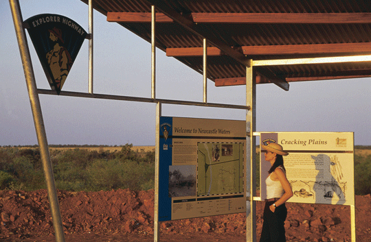
Newcastle Waters
Located at the junction of three major overland stock routes,
Newcastle Waters was an important gathering place for drovers
to provision and rest before continuing on with their gruelling
overland cattle drives. The Newcastle Waters township, located
269 kilometers north of Tennant Creek, is part of a large, historic
cattle station in the Barkly Tablelands.
Elliott - BP Fuels
255 kilometers north of Tennant Creek and 23 km to the south
of Newcastle Waters is the small town of Elliott. or 100kms south
of Dunmarra and 85kms north of renner Springs.
Renner Springs
Renner Springs, now a roadhouse and motel, was originally
a medical post for the workers constructing the Overland Telegraph
Line in the 1870s. Its name derives from Doctor Charles Renner,
who was the physician there, and the fact that there are numerous
springs in the area. Renner Springs takes pride in the level of
service and quality of product it delivers, and clientele can
be assured of a memorable experience of hospitality, and "a little
bit of desert magic" whenever they visit.
Stuart Memorial Stuart Highway Northern Territory
Today, his name is perpetuated by: The Stuart Highway linking
Adelaide to Darwin. Explorer: The Overland Telegraph Line, linking
Adelaide to Europe via Darwin, was constructed along his route.
South Australia established settlement on the north coast at Darwin
and vast areas of the north were opened up for pastoral and mineral
development.
John Flynn Memorial
Flynn's work is perpetuated throughout the outback in many
ways. The Royal Flying Doctor Service and the Australian Inland
Mission are working testimonials to his drive and vision. In 1956
the Flynn Memorial Church was dedicated in Alice Springs; at Threeways,
north of Tennant Creek a massive monument marks the junction of
the Barkly Highway from Queensland and the Stuart Highway to Darwin,
it is called the Flynn Memorial.
Threeways to Barrow Creek - 248 klm
Three Ways Roadhouse, Stuart Highway Northern Territory
Travelling north from Tennant Creek towards Katherine on the
fast, straight Explorer’s Way, you pass through golden grasslands
that slowly give way to Savannah woodland. Along the way, reminders
of the past abound from the region’s pioneering, pastoral and
Second World War history. Three Ways is a roadhouse located at
the junction of the Stuart and Barkly Highways, 25 kilometers
north of Tennant Creek. This a great place to take a break and
unwind during a long journey, all while enjoying warm Northern
Territory hospitality.
Bridge over Attack Creek north of Three Ways
74 kilometers north of Tennant Creek is a monument marking
the point where explorer John McDouall Stuart turned back on his
expedition to cross the continent in 1860 after a hostile encounter
with some local Aboriginal people. It has since been appropriately
known as Attack Creek.
Tennant Creek Stuart Highway Northern Territory
Tennant Creek in Central Australia sits on the Explorer’s
Way, 500 kilometers north of Alice Springs and 1000 kilometers
south of Darwin. To the east of town is the Barkly Tablelands
- an expanse of land that supports some of Australia’s premier
outback cattle stations.Tennant Creek’s history is shaped by gold
mining, Aboriginal culture and pastoralism. The region's rich
mining history can be explored at Battery Hill Mining Centre,
the site of Australia's last major gold rush in the 1930s. Visitors
can even try fossicking for their own gold.
Tennant Creek - Mary Anne Dam
Mary Ann Dam Recreation Lake is a cool oasis, five kilometers
north of Tennant Creek. This man made dam is a pleasant surprise
in a rugged, Central Australian environment, offering an ideal
picnic spot where the lake provide a cool oasis for locals and
tourists alike and is large enough to allow for canoeing, windsurfing
and other water sports.
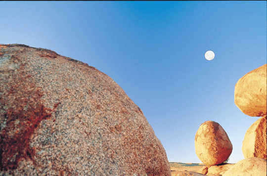
Karlu Karlu / Devils Marbles Conservation Reserve
Free entry (Aboriginal Culture) (Aboriginal Self Discovery)
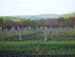
The Karlu Karlu / Devils Marbles are clusters of mysterious rock
spheres located in the scenic Australian desert near the outback
town of Tennant Creek, scattered in heaps throughout a wide, shallow
valley. The boulders, which are often precariously balanced on
top of one another, were formed by millions of years of erosion.
The local Aboriginal people, the Warumungu, believe that the boulders
are the eggs of the Rainbow Serpent. The ancient Aboriginal mythology
surrounding this fascinating geological marvel can be explored
through a short self-guided walking trail and informative signage.
The Karlu Karlu / Devils Marbles Conservation Reserve, stretching
over 1,802 hectares, is home to a wide variety of unique desert
flora and fauna, including goannas and finches. The reserve is
located approximately 400 kilometers north of Alice Springs or
100 kilometers south of Tennant Creek. The nearest town, Wauchope,
offers a limited range of accommodation and facilities.
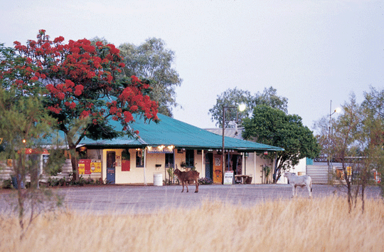
Wauchope Hotel and Roadhouse
This historic pub dates back to the 1930s, when Wolfram was mined
nearby. Today Wauchope Hotel provides comfortable cabins or caravan
park accommodation, food and refreshments for travellers who want
to experience the hospitality for which the outback is famous.
Wauchope Hotel and Roadhouse is also the closest accommodation
to the Karlu Karlu / Devils Marbles.
Wycliffe Well Holiday Park
Wycliffe Well is an oasis in the desert, and Australia’s UFO
hot spot. Wycliffe Well is located 380 kilometers north of Alice
Springs on the Stuart Highway, perfectly situated as a stop over.
Wycliffe Well Holiday Park occupies a land area of approximately
60 acres, housing onsite accommodation options, grassed unpowered
spaces and powered sites. The park is only a few minutes drive
to one of the Northern Territory’s most renowned attractions,
the Karlu Karlu / Devils Marbles Conservation Reserve. There is
also an auditorium, bar, animal sanctuary, a large fishing/crabbing
lake, restaurant and stage with an Aboriginal performance theme.
Wycliffe Well is also home to one of the largest range of beers
in Australia.
Banka Banka Station Stuart Highway Northern Territory
Banka Banka Station was the first operational cattle lease
in this region and also served as an army camp during World War
II. Visitors can camp overnight at the station and learn about
its past. The mudbrick Banka Banka homestead is situated approximately
100km north of Tennant Creek and about 100m west of the Stuart
Highway on Banka Banka Station.
Threeways to Barrow Creek - 248 klm
Barrow Creek Hotel
The Barrow Creek Hotel is on the road between Alice Springs
and Tennant Creek and is a popular stop for travellers along the
highway. The old pub was built in 1926 and it still has the original
old bar, underground cellar and tin ceilings, and contains a tremendous
collection of memorabilia and items of interest which have been
gathered over the years. It is worth stopping at the Barrow Creek
Hotel to enjoy the publican's hospitality and to hear how Barrow
Creek came to be an important outpost on the Overland Telegraph
line. There's demountable accommodation outside, rooms inside
and a caravan park.
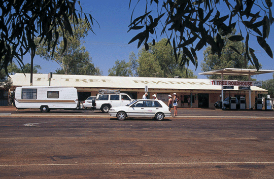
Ti Tree Roadhouse
Is a town in the Northern Territory along the Stuart Highway
193 km north of Alice Springs, 311 km south of Tennant Creek &
1289 km south of Darwin in Australia. It is the closest town to
Alice Springs. The area around Ti Tree has a population of 995
people. The population is distributed between the 11 cattle stations,
6 Aboriginal outstations including Utopia, Ti Tree township, Barrow
Creek community & the agricultural produce farms of Ti Tree Farm,
Central Australian Produce Farm & the Territory Grape Farm. The
area is an emerging centre for grapes & melons due to its year-round
sunshine & abundant underground water supply. A famous landmark
to the north of Ti Tree is Central Mount Stuart.
Plenty Highway turn off
58Kms from Bond Springs going north Travelling from Alice
Springs past the Bond Springs turnoff turn off right to go onto
the Plenty Highway and a further 27km to turn left up to the Sandover
Highway.
Tropic Of Capricorn Marker
The Tropic of Capricorn crosses the Stuart Highway 30 kilometers
north of town. There is a monument marking the spot and a parking
area. The Tropic separates the tropic (to the north) and temperate
zones. It passes through Rockhampton on the east coast of Queensland.
The Tropic of Capricorn Marker, a Bicentennial community project,
is set back 15 metres from the road, along the Stuart Highway
30 kilometers north of Alice Springs.
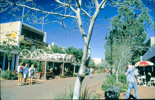
Alice Springs
Alice Springs - The heart of Central Australia is comprised
of cavernous gorges, boundless desert landscapes, remote Aboriginal
communities and a charming pioneering history.
©
source | courtesy of darwintoalicesprings.com
©
source | courtesy of outbacktravellers.com.au
|
 ©
© ©
© ©
© ©
© ©
© ©
© ©
© ©
© ©
© ©
© ©
© ©
©

